Thursday, May 25, 2017

Florence, AL to Grand Rivers, KY

Total Miles Traveled 3663

After anchoring a few days on the 43,000 acre Pickwick Lake, we entered the final lock of our adventure at Pickwick Dam dropping over 50 feet to the beginning of Kentucky Lake on the Tennessee River.  When traveling up the waterway from Mobile to Pickwick Lake, we were against the current, but after locking through the Pickwick lock, we are traveling with the current.  We only lost about 1 mph on the way up, but picked up about 2 mph after locking through as the Tennessee River and Kentucky Lake were about 3 feet above normal pool and Kentucky Dam was discharging water at a higher rate.  The Tennessee and Cumberland Rivers are two of only a few rivers in North America that flow North. 


With a higher than normal river stage and current, and the possibility of thunderstorms, we decided to stop at two marinas on the way up to Kentucky Lake rather than anchoring out.  We stopped at the Clifton Marina and the Pebble Isle Marina; both marinas are great stops with very friendly people and protected from the weather.  Our first anchorage on Kentucky Lake was Sugar Bay, this is a well-protected anchorage from all directions and with a good chance of thunderstorms, we stayed here two nights.  We had rain, and some wind but nothing severe.


While sitting on the fly bridge drinking my morning tea, I heard a heck of a racket at the nearby boat ramp.  Three trucks pulled up, two of them with boats and one with a trailer….full of bathtubs.  They unloaded the bathtubs into the boats and launched them.  The only thing I could figure is they were building an artificial reef to attract fish somewhere on the lake. 


We arrived at our home port at Green Turtle Bay, Grand Rivers Kentucky Saturday May 20th.  We arrived 190 days after starting in November 2016 and traveling 3663 miles.  We made a lot of new friends, some of them loopers, that we will meet again as they complete the river section of the loop this fall. 

Friday, May 12, 2017

Pickwick Lake to Florence, AL

Total Miles Traveled 3426

With the threat of possible storms moving through, we left our anchorage and arrived at the Florence Harbor Marina, Friday May 11th.  We bypassed this stop during the loop last year, but made it a priority this year so we could visit the city across the river, Muscle Shoals.

Muscle Shoals is known for recording many hit songs from the 1960’s to today at two studios:  FAME Studios, founded by Rick Hall, and the Muscle Shoals Sound Studio, founded by the musicians known as The Swampers.  The Swampers, a nickname given to The Muscle Shoals Rhythm Section, was a local group of first-call studio musicians, initially working at FAME and then at Muscle Shoals Sound Studios.


 Jerry Wexler and Willie Nelson

Original receipt for the Rolling Stones recording of "Wild Horses"


Just a sampling of the bands and artist that have recorded at the studios:  Lynyrd Skynyrd, Rolling Stones,   Aretha Franklin, Etta James, Paul Simon, Rod Stewart, Bob Seger, Wilson Pickett, Cher, The Staple Singers, Clarence Carter, Loue Rawls, Percy Sledge, The Osmonds, Candi Staton, Joe Cocker, Dire Straits, James Brown, Jimmy Buffett, Bob Dylan, Willie Nelson, Steve Winwood, Allman Brothers, Carrie Underwood and many more.

The 2013 documentary “Muscle Shoals” tells the amazing story of the formation of the two recording studios and the mystical draw of artist all over the world.

Wednesday, May 10, 2017

Demopolis, AL to Pickwick Lake, AL

Total Miles Traveled 3400

On May 4th we left Demopolis not knowing what river conditions to expect after the storms moved through.  We were surprised to find very little debris and river levels to be near summer pool.  We traveled 53 miles to Sumpter Recreation Area, this is a small basin cut out from the river with a boat ramp and small campground, a great place to get off the river for the night. 


Our next planned stop was the Columbus Mississippi Marina, where we were going to catch up with “0 Regrets”.  We passed two tows on the way, the last one about 5 miles from the Tom Bevell Lock.  When we arrived at the lock, another tow was just entering the lock.  I asked the lockmaster if we could possibly lock through with the tow but was informed the tow was red flagged (hauling fuel) and it would not be permitted.  He also informed us we would have to wait until the tow we passed earlier locked through.   We dropped the hook out of the channel and ate lunch waiting for our turn.  With a two and a half hour delay, and two tows ahead of us, we anchored in an oxbow next to the town of Columbus.

We left our anchorage at Columbus, MS on May 6th and made the run to the Glover Wilkins Lock without any barge traffic slowing us down, the lock masters even called the next lock for us and let them know we were coming so they had the lock chamber empty and waiting for us.  After locking through the Glover Wilkins Lock, we anchored in a small basin on the east side of the lock.

Four more locks and we will be at the highest elevation (414 feet above sea level) of the Tenn-Tom Waterway.  We arrived at the last lock, the Jamie Whitten Lock, the highest lift of the Tenn-Tom waterway of 84 feet.


After locking through, we entered Bay Springs Lake and traveled a short distance to the Bay Springs Marina.
 

On Monday, May 8th we left the marina, crossed Bay Springs Lake, and entered the Divide Cut. The Tenn-Tom Waterway was cut through the backbone of the land here to a depth of as much as 175 feet for a distance of nearly 25 miles.  


We arrived at mile 450.7 on the Tenn-Tom Waterway, the junction of the Tennessee River, mile 215.2 and Pickwick Lake.   We turned south and anchored in a cove on Panther Creek.  What a great anchorage, we really missed the hills, tall trees, lake coves, owls, crickets, frogs, and the birds singing. 


We had fun catching fish too…..


Guess who won the biggest fish contest….it wasn’t the guy taking the picture.  It weighed in at 4 lbs.


These  guys would show up every morning and set drop lines in the middle of the cove, fish until noon, pull their lines and leave.  We watched them land a few nice catfish.


We weighed anchor this morning May 10th and traveled 11 miles to the Rock Pile.  We anchored here when we started the loop in 2015.


Monday, May 1, 2017

Mobile, AL to Demopolis, AL

Total Miles Traveled 3142

We left Turner Marine early April 25th and traveled only 14 miles up Mobile Bay to the Mobile Convention Center City dock.  This free dock is located a short walk to the historic district and Main Street. 


We passed a few fishing boats and a dredge on the way.


After a walk up and down main street, and a break for lunch, we walked to the historical museum covering the port city’s history going back 300 years.  I thought the civil war submarine H.L. Hunley, built in Mobile in 1863, had an interesting story.  It was the first combat submarine to sink a warship, but following her successful attack, was lost along with her crew before she could return to base.


After visiting the museum, we took a narrated tour bus ride around the city learning the history of this historic town.


One of the most surprising things we learned was that the Mardi Gras celebration started in Mobile in 1703, fifteen years before New Orleans was founded.


Something we found odd while on our tour was the New Year’s Eve celebration in Mobile.  Instead of lowering a ball from a tall building in the city during the countdown, they lower a 12 foot tall lighted Moon Pie.  A Moon Pie is a graham cracker cookie with marshmallow filling in the center, dipped in a flavored coating and made by the Chattanooga Bakery, in Chattanooga Tennessee.  The Moon Pie became the traditional item thrown from a parade float, into the crowd, during Mardi Gras in 1956.  Our tour guide pointed out the previous item was boxes of Cracker Jack’s.  I guess I would much rather be hit upside the head with a flying Moon Pie than a box of Cracker Jack’s.


An unexpected part of our tour was entering a tunnel that drops 40 feet under the Mobile River, taking us to the USS Alabama Memorial Park.  The USS Alabama is a battleship of the United States Navy that served in World War II in the Atlantic and Pacific theaters. 


Also located at the park is the B-52 bomber Stratofortress Calamity Jane, a long-range, subsonic, jet-powered strategic bomber.  The bomber is capable of carrying up to 70,000 pounds of weapons, and has a typical combat range of more than 8,800 miles without refueling. 


Our first realization that we are heading back home, we had to wait at this railroad crossing while walking back to the boat.  I don’t think we have been railroaded since leaving Terre Haute, IN.


Just across the river from our boat is the Austal ship building company employing over 4000 employees and contractors.   One of their major contracts is with the United States Navy, building the Littoral (close to shore) Combat Ship (LCS).  I thought this ship was ready for painting, but found the design and existing paint is radar reflective.


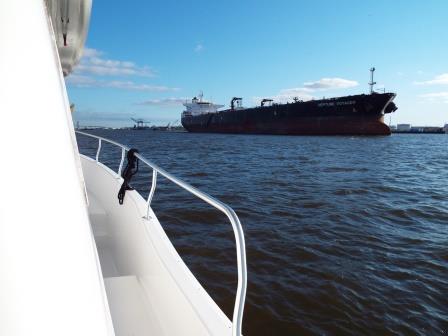
Waiting for a ship to pass before leaving Mobile.


We left Mobile entering the Black Warrior-Tombigbee waterway and anchored in the Alabama River Cutoff Wednesday April 26th.  There are no marinas and few good places to anchor in the 160 mile stretch between Mobile and Demopolis Alabama.  This is our anchorage at Okatuppa Creek April 27th.


And our anchorage at Bashi Creek April 28th.


While anchored at Bashi Creek, our fellow looper “0 Regrets” showed up to anchor for the night.  We haven’t seen Barry since leaving Panama City but will travel together  to Demopolis.


This alligator was swimming across the river just after the Coffeeville Lock and Dam.


One of the best investments we made when preparing our boat for the Great Loop was the purchase of an AIS system.  The Automatic Identification System is an automatic tracking system used for collision avoidance.  I have our system set up to alert me when another vessel transmitting an AIS signal is within 2 miles of our position.  I can see the name, speed and direction of travel of the approaching vessel, and they can see my information.  As we were approaching a bend in the river, I called the approaching tow  by radio and asked which side of the river he would like me to be on during our pass.  He responded that the approaching bend would be tight for him and asked if I would hold position until he made the turn.  Without AIS we would have met in the river bend with nowhere to go but to shore.


We arrived at Demopolis the next day staying at Kingfisher Bay Marina.  A major storm system was approaching from the west and arriving in our area on the 30th so we wanted to be off of the river and secured to a dock before it arrived.  As luck would have it, we didn’t get any severe weather but a lot of rain.  The river isn’t expected to crest for a few days so we will stay here until things settle down.